AWS Public Sector Blog
How open data from weather radar helps scientists improve environmental understanding

Airplanes make it safely to their destinations through continuous monitoring of atmospheric weather with radar networks. These weather radar networks are able to see cloud droplets and compute if the droplets are moving away from or towards the radar. This occurs by sending out a radio pulse and measuring how long it takes the radio wave to bounce back off the cloud droplets. The power of the return radio wave is translated into the reflectivity while the frequency is used to compute the droplet velocity through the Doppler effect. These two variables—reflectivity and velocity—yield signification information about what is happening inside a cloud and the atmosphere overall.
Weather radars are, amongst other things, able to detect the intensity of rain, the presence of hail, the potential size of the hail, if a thunderstorm is producing a tornado, and if a tornado is lofting debris into the atmosphere. These variables also enable weather radars to see more than just the weather. Weather radars are capable of seeing smoke from fires, meteors, birds, mayflies, and almost anything else in the atmosphere. This makes weather radars an invaluable tool for scientists seeking to further the understanding of atmospheric processes and anything else that happens to be flying through the radar’s field of view.
Long periods of weather radar data are used to compute climatologies—the long term trends—of the observed weather. These climatologies are useful for understanding how climate change is impacting the weather, and for improving the forecasting of severe weather events. Weather radar-based climatologies of hail are being integrated into the forecasting process to improve alerts for severe weather. Climatologies of rain are used to build and verify flash flood models to enable timely and more accurate flash flood warnings.
The Amazon Sustainability Data Initiative (ASDI) seeks to accelerate sustainability-related innovation and research by helping to minimizing the cost and time required to store, acquire, and analyze large weather and climate datasets. ASDI supports practitioners, innovators, and researchers with the data, tools, and technical expertise to advance sustainability work, goals, and initiatives. ASDI supports collaborations with governments and national hydrometeorological services around the world. Several of these collaborators including the U.S. National Oceanic and Atmospheric Administration (NOAA), Finnish Meteorological Institute (FMI), and the Colombian Institute of Hydrology, Meteorology and Environmental Studies (IDEAM)—all who are sharing weather radar data as part of ASDI.
Through a collaboration with NOAA and its Big Data Program (BDP), ASDI is making available the complete NOAA Next Generational Weather Radar (NEXRAD) Level II historical archive, originating in 1991, on Amazon Web Services (AWS) to help monitor the atmosphere. The archive is updated in real time with new data from the 160 radars in the network and are updated continuously. Since the NEXRAD archive was incorporated into the BDP and made available on AWS, the amount of data accessed has increased 130 percent.
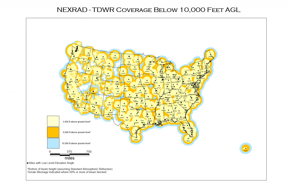
Figure 1. Weather radar locations and coverage from the NOAA NEXRAD network across the conterminous US and Puerto Rico.
ASDI also makes available weather radar data from the FMI and weather radar data from IDEAM in Colombia. Radar data from FMI are available from 12 radars covering Finland spanning a time period of 2007 through present with the data updating in real time. The FMI data are in volumetric files similar to the NEXRAD data, and are also converted into the geotiff format making it ideal for web mapping applications. The data from IDEAM consist of volumetric files available from 2018 through present time available from three radars covering parts of Colombia. The IDEAM data are delayed 24 hours before being made available.
One user of the weather radar data on AWS, DTN, a data analytics and technology company, makes visualizations and analyses available to consumers through the popular Radarscope application. Mike Wolfinbarger, vice president of mobile development at DTN, says, “Having the archive of weather radar data available on AWS enables us to offer an order of magnitude more data for our customers to be able to explore historical weather events. All of the data being on Amazon Simple Storage Service (Amazon S3) means a unified API for accessing it, which makes it even easier to incorporate new weather radar networks as they become available too.”

Figure 2. The Radarscope application used to visualize NOAA NEXRAD data from ASDI.
These collaborations leverage the AWS Open Data Sponsorship program to host foundational data on AWS, covering the storage and egress costs for qualifying datasets and allowing data providers to retain complete control and ownership of their data hosted on AWS.
ASDI is expanding its weather radar catalog and accepting submissions for authoritative radar datasets that can help advance sustainability innovation and practice. If you have weather radar data to share, consider applying for the AWS Open Data Sponsorship program. To find all of the data being made available through the AWS Open Data Sponsorship program, check out the Registry of Open Data on AWS.
Learn more about the Amazon Sustainability Data Initiative (ASDI). Read more ASDI and sustainability stories.
Subscribe to the AWS Public Sector Blog newsletter to get the latest in AWS tools, solutions, and innovations from the public sector delivered to your inbox, or contact us.